


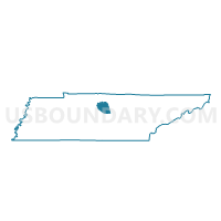
06 Carroll-Oakland School Voting District, Wilson County, Tennessee
About
Outline

Summary
| Unique Area Identifier | 670042 |
| Name | 06 Carroll-Oakland School Voting District |
| County | Wilson County |
| State | Tennessee |
| Area (square miles) | 44.08 |
| Land Area (square miles) | 42.30 |
| Water Area (square miles) | 1.78 |
| % of Land Area | 95.97 |
| % of Water Area | 4.03 |
| Latitude of the Internal Point | 36.29474640 |
| Longtitude of the Internal Point | -86.24769650 |
Maps


Graphs
Select a template below for downloading or customizing gragh for 06 Carroll-Oakland School Voting District, Wilson County, Tennessee


Neighbors
Neighoring Voting District (by Name) Neighboring Voting District on the Map
- 03 Castalian Springs Voting District, Sumner County, TN
- 04 Rock City Voting District, Smith County, TN
- 05 Berea Church of Christ Voting District, Wilson County, TN
- 10th Providence Voting District, Trousdale County, TN
- 15 Full Gospel Tabernacle Voting District, Wilson County, TN
- 19 Jimmy Floyd Family Center Voting District, Wilson County, TN
- 6th Walnut Grove Voting District, Trousdale County, TN
Top 10 Neighboring County Subdivision (by Population) Neighboring County Subdivision on the Map
- District 3, Sumner County, TN (12,840)
- District 5, Wilson County, TN (6,291)
- District 19, Wilson County, TN (4,980)
- District 15, Wilson County, TN (4,086)
- District 6, Wilson County, TN (3,981)
- District 4, Smith County, TN (2,534)
- District 6, Trousdale County, TN (912)
- District 10, Trousdale County, TN (764)
Top 10 Neighboring Place (by Population) Neighboring Place on the Map
Top 10 Neighboring Elementary School District (by Population) Neighboring Elementary School District on the Map
Top 10 Neighboring Secondary School District (by Population) Neighboring Secondary School District on the Map
Top 10 Neighboring Unified School District (by Population) Neighboring Unified School District on the Map
- Sumner County School District, TN (160,645)
- Wilson County School District, TN (84,298)
- Smith County School District, TN (19,166)
- Trousdale County School District, TN (7,870)
Top 10 Neighboring State Legislative District Lower Chamber (by Population) Neighboring State Legislative District Lower Chamber on the Map
- State House District 57, TN (84,276)
- State House District 44, TN (70,843)
- State House District 46, TN (68,934)
- State House District 40, TN (60,137)
Top 10 Neighboring State Legislative District Upper Chamber (by Population) Neighboring State Legislative District Upper Chamber on the Map
Top 10 Neighboring 111th Congressional District (by Population) Neighboring 111th Congressional District on the Map
Top 10 Neighboring Census Tract (by Population) Neighboring Census Tract on the Map
- Census Tract 301.01, Wilson County, TN (7,421)
- Census Tract 301.02, Wilson County, TN (6,640)
- Census Tract 305, Wilson County, TN (6,255)
- Census Tract 9752, Smith County, TN (5,634)
- Census Tract 901, Trousdale County, TN (5,390)
- Census Tract 206.03, Sumner County, TN (3,243)